CERENA Seminar - October
On October 12 at 2 PM, we will have the following talks:
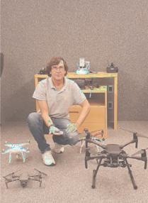
Mapping and modelling using remote sensing boarded in UAVs applied to surface mining by Rodrigo Peroni
On October 12 at 2 PM, we will have the following talks:
Mapping and modelling using remote sensing boarded in UAVs applied to surface mining by Rodrigo Peroni
On June 27 at 130pm, we will have the following talks:
Circular economy and revalorisation of NORM waste: examples from gold mining in South Africa by Frank Winde
In the end of April, Amélia Lemos, Francisco Lemos, and Rosana Pinto participated in the Department of Chemical Engineering (DEQ) of Instituto Superior Técnico Open Laboratories. Amélia and Francisco Lemos gave a talk about how engineering could be used to serve humanity, while Rosana focused on how metallic organic frameworks can be used as magical sponges of the future.
Waste resulting from coal and mineral mining, such as Au-As, Sb-Au, and W, deposited in tailings ponds, represents a source of pollutants. Particles released into the atmosphere by wind, as well as the mobilization and leaching of potentially hazardous, phytotoxic, and zootoxic elements, affect the quality of air, soil, surface water, and groundwater, causing environmental pollution and impacts on biodiversity and human health.
The students from the Mining and Geoenvironment Bachelor's and Master’s Degree, as well as the Environment Engineering Bachelor’s and Master’s Degree, participated in the Meeting of Young Researchers of U.Porto (IJUP).
On 6th May 2026, Ana Filipa Duarte and Omri Gadol went to the European Geosciences Union General Assembly, which took place in Vienna, where they presented their work.
The DAEDALUS project aims to uncover how warm-bloodedness (endothermy) developed in birds and their dinosaur ancestors by studying the semicircular canal system in the inner ear (or labyrinth), vital for balance and orientation. The principle: as fluid warms, it becomes less viscous. Thus, as early endotherms evolved endothermy, their ear canal fluid's viscosity decreased, leading to necessary adaptations in canal morphology and/or physicochemical properties for survival.
Have you ever wondered why a phenomenon occurs in a specific location? What tools do we have to model and predict phenomena with a significant spatial component? Spatial Data Science offers insights into these questions.
Spatial Data Science is an interdisciplinary field that integrates traditional data science methods-such as Machine Learning and Artificial Intelligence-with spatial analysis methodologies, including Geographic Information Systems, Geostatistics, and Remote Sensing. This combination enables us to understand, characterize, and manage big spatial data.
On 4th May 2026, Ricardo Araújo participated in the presentation session of AKDN-FCT Projects, where he presented PaleoMoz’s latest results.